
Training on Introduction to Geographic Information Systems (GIS)
Master the fundamentals of Geographic Information Systems (GIS). Learn to visualize, analyze, and interpret geographic data to gain valuable insights and make informed decisions.
Next intake
20 Jul 2026 · Nakuru
Duration
10 days
Live instruction
Delivery
Physical + Virtual
Cohort based
Level
Advanced
Working professionals
Certification
NITA reimbursable
For Kenyan cohorts
Language
English
All materials
About this programme
This course provides a comprehensive introduction to Geographic Information Systems (GIS), a powerful tool for spatial data analysis, mapping, and decision-making across various industries. Participants will gain an understanding of the fundamental concepts of GIS, including data types, spatial analysis, and map creation. Through hands-on exercises and practical examples, learners will explore how GIS can be used to visualize and analyze spatial data, solve real-world problems, and enhance decision-making processes. This course is ideal for beginners who want to build a strong foundation in GIS.
Course Duration
10 Days
Who Should Attend
- Professionals new to GIS and spatial data analysis.
- Environmental scientists, urban planners, and geographers.
- Students and researchers in geography, geology, environmental science, or related fields.
- Individuals interested in mapping and spatial data visualization.
- Decision-makers and analysts looking to incorporate spatial analysis into their workflows.
What you'll walk away with
By the end of this course, participants will be able to:
- Understand the basic concepts and components of Geographic Information Systems (GIS).
- Identify different types of spatial data and their applications.
- Use GIS software to create, manipulate, and analyze spatial data.
- Develop skills in map design and cartographic principles.
- Perform basic spatial analysis to solve real-world problems.
- Apply GIS in various sectors such as environmental management, urban planning, and resource management.
- Interpret and communicate spatial information effectively through maps and reports.
- Understand the role of GIS in decision-making processes.
- Explore the latest trends and developments in GIS technology.
- Build a strong foundation for advanced GIS studies or professional applications.
What we cover, module by module
Module 1: Introduction to Geographic Information Systems (GIS)
- Definition, history, and evolution of GIS technology
- Core concepts: spatial thinking, geographic data, and spatial relationships
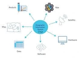
- Components of a GIS system: hardware, software, data, people, and methods
- Role of GIS in decision-making and problem-solving
- Applications of GIS across sectors such as health, agriculture, urban planning, and environment
- Overview of spatial problem-solving using GIS
- Case Study: Use of GIS in disaster response planning and resource allocation
- Practical Exercise: Exploring GIS software interface and identifying spatial datasets for a real-world problem
Module 2: Spatial Data Fundamentals
- Types of spatial data: vector and raster data models
- Coordinate reference systems and map projections
- Data accuracy, scale, and resolution in GIS
- Sources of spatial data: GPS, remote sensing, surveys, and open data platforms
- Data formats (Shapefile, GeoJSON, TIFF, KML)
- Data quality assessment and metadata importance
- Case Study: Using spatial data to map population distribution and service accessibility
- Practical Exercise: Importing and converting spatial datasets with different coordinate systems
Module 3: Data Management and Spatial Analysis
- Importing, exporting, and managing spatial datasets
- Data cleaning, transformation, and preprocessing techniques
- Spatial data integration and geodatabase management
- Buffer analysis and proximity studies
- Overlay analysis for decision-making
- Spatial interpolation techniques (IDW, Kriging basics)
- Data validation and quality control
- Case Study: Land suitability analysis for agricultural development using GIS
- Practical Exercise: Performing buffer and overlay analysis on real spatial datasets
Module 4: GIS Software Fundamentals
- Overview of GIS software: QGIS, ArcGIS, and open-source tools
- Installation, setup, and workspace configuration
- Understanding the GIS interface and toolbars
- Layer management and attribute tables
- Creating, editing, and symbolizing spatial data
- Saving and managing GIS projects
- Case Study: Developing a municipal land use map using QGIS or ArcGIS
- Practical Exercise: Creating and editing spatial layers for a simple mapping project
Module 5: Spatial Data Visualization and Cartography
- Principles of effective map design and communication
- Map layout elements: legend, scale bar, north arrow, title, and annotations
- Thematic mapping techniques: choropleth, heat maps, proportional symbols
- Color theory and visual hierarchy in cartography
- Labeling, symbolization, and map aesthetics
- Exporting maps for print and digital use
- Case Study: Creating demographic distribution maps for policy planning
- Practical Exercise: Designing a thematic map with proper cartographic standards
Module 6: Spatial Analysis Techniques
- Distance and proximity analysis (buffer zones, nearest neighbor analysis)
- Network analysis for routing and accessibility
- Terrain analysis using Digital Elevation Models (slope, aspect, contouring)
- Spatial statistics and pattern analysis
- Hotspot analysis and density mapping
- Multi-criteria decision analysis (MCDA) in GIS
- Case Study: Route optimization for emergency response services
- Practical Exercise: Performing network and terrain analysis using GIS tools
Module 7: Web Mapping and Online GIS
- Introduction to web GIS and digital mapping platforms
- Publishing and sharing maps online
- Web map services (WMS, WFS)
- Interactive map creation using GIS tools
- Cloud-based GIS platforms and collaboration tools
- Introduction to Story Maps and dashboard visualization
- Case Study: Development of an interactive public health GIS dashboard
- Practical Exercise: Creating and publishing a simple web map using GIS platforms
Module 8: Advanced GIS Topics and Applications
- Geoprocessing automation and scripting (Python in GIS)
- Spatial Decision Support Systems (SDSS)
- Remote sensing integration with GIS
- Artificial intelligence and machine learning in GIS
- Big data and real-time GIS applications
- Advanced spatial modeling techniques
- Case Study: Using GIS automation for environmental monitoring and reporting
- Practical Exercise: Automating a GIS workflow using basic scripting tools
Module 9: GIS Applications in Key Sectors
- GIS for urban and regional planning
- Environmental monitoring and conservation
- Natural resource and agricultural management
- Transportation and logistics planning
- Disaster risk management and emergency planning
- Public health and epidemiology applications
- Case Study: GIS application in urban traffic congestion and planning
- Practical Exercise: Developing a sector-specific GIS analysis project
Module 10: GIS Project Development and Presentation
- Designing a complete GIS project workflow
- Data collection, analysis, and interpretation
- Map production and visualization techniques
- Report writing and documentation standards
- Presenting GIS findings to stakeholders
- Case Study: End-to-end GIS project for environmental or urban planning
- Practical Exercise: Developing and presenting a full GIS project from data to final map outputs
Where the change lands
Organisational Impact
-
Builds foundational capacity for integrating GIS into organisational workflows and projects.
-
Enhances decision-making by enabling teams to visualize and analyze spatial data effectively.
-
Supports a wide range of applications, from environmental monitoring to urban planning and resource management.
-
Reduces reliance on external GIS specialists by empowering staff with in-house skills.
-
Provides a scalable foundation for adopting more advanced GIS and remote sensing applications.
Personal Impact
-
Equips participants with essential GIS skills for mapping, spatial analysis, and data visualization.
-
Builds confidence in applying GIS to solve real-world problems across different sectors.
-
Expands career opportunities in environmental science, planning, research, and data analysis.
-
Provides hands-on experience in creating maps and analyzing spatial datasets.
-
Empowers participants to build a strong GIS foundation, preparing them for advanced geospatial training.
Dates and locations
Upcoming intakes
Every intake is limited to a small cohort. Booking closes when a date fills or three weeks before the start, whichever comes first.
| City | Starts | Ends | Delivery | Book |
|---|---|---|---|---|
NakuruNext | 20 Jul 2026 | 31 Jul 2026 | In-Person | Book |
Kigali | 20 Jul 2026 | 31 Jul 2026 | In-Person | Book |
Accra | 20 Jul 2026 | 31 Jul 2026 | In-Person | Book |
Kisumu | 27 Jul 2026 | 07 Aug 2026 | In-Person | Book |
Johannesburg | 27 Jul 2026 | 07 Aug 2026 | In-Person | Book |
Dakar | 27 Jul 2026 | 07 Aug 2026 | In-Person | Book |
- NakuruNext
20 Jul → 31 Jul·In-Person
Book this intake - Kigali
20 Jul → 31 Jul·In-Person
Book this intake - Accra
20 Jul → 31 Jul·In-Person
Book this intake - Kisumu
27 Jul → 07 Aug·In-Person
Book this intake - Johannesburg
27 Jul → 07 Aug·In-Person
Book this intake - Dakar
27 Jul → 07 Aug·In-Person
Book this intake
Common questions.
Still not sure? Send us a note and a facilitator will get back to you within a business day.
You may also like.
Programmes in the same discipline that participants often pair with this course.
 Hybrid10 days
Learn AI and computer vision for urban growth monitoring and informal settlement mapping using satellite imagery, GIS, deep learning, and spatial analytics.
 Hybrid10 days
Learn AI-powered disaster damage assessment using satellite imagery, machine learning, GIS, and remote sensing for rapid response and recovery planning.
 Hybrid10 days
Learn AI-powered water body and flood extent mapping using SAR data, machine learning, GIS, and remote sensing for disaster management and water resources.
Course finder
Find the right course for you
Prefer to talk it through? Send us an enquiry and a facilitator will scope a fit within a business day.
For corporate teams
Training 10+ professionals?
We deliver Training on Introduction to Geographic Information Systems (GIS) in-house at your offices, at a venue we arrange, or fully virtual. Customise the curriculum against your KPIs, and get a bespoke price for the cohort size you need.