
Training on Introduction to GIS using ArcGIS and QGIS
Master GIS fundamentals with ArcGIS and QGIS. Learn to visualize, analyze, and interpret geographic data to gain valuable insights.
Next intake
20 Jul 2026 · Nakuru
Duration
10 days
Live instruction
Delivery
Physical + Virtual
Cohort based
Level
Advanced
Working professionals
Certification
NITA reimbursable
For Kenyan cohorts
Language
English
All materials
About this programme
Welcome to our comprehensive course on Introduction to GIS using ArcGIS and QGIS! In this course, we will take you on a participants through the fascinating world of Geographic Information Systems (GIS) and provide you with a solid foundation in two of the most widely used GIS software platforms: ArcGIS and QGIS.
GIS is a transformative technology that enables us to capture, analyze, and visualize spatial data, allowing us to gain valuable insights into the world around us. Whether you're interested in urban planning, environmental conservation, disaster management, or any field where location plays a crucial role, GIS will empower you to make informed decisions and solve complex problems.
Throughout this course, we will cover essential GIS concepts, such as spatial data types, coordinate systems, and data acquisition methods. You will learn how to manage and manipulate spatial data effectively, conduct spatial analysis to reveal meaningful patterns and relationships, and design professional-quality maps for effective communication of your findings.
Our hands-on approach will provide you with practical experience using ArcGIS and QGIS. Through step-by-step learning and real-world examples, participants will gain the confidence to navigate the software interfaces, perform essential tasks, and apply GIS techniques to real-world scenarios.
Course Duration
10 Days
Who Should Attend?
- Beginners and professionals who are new to GIS and want to develop foundational skills.
- Environmental scientists, urban planners, geographers, and professionals from related fields looking to incorporate GIS into their work.
- Students and researchers in disciplines that require spatial analysis and mapping.
- Anyone interested in understanding how to use GIS for spatial data analysis and decision-making.
What you'll walk away with
By the end of this course, participants will be able to:
- Understand the basic concepts and principles of GIS.
- Navigate and utilize the interfaces of ArcGIS and QGIS.
- Collect, manage, and manipulate spatial data.
- Perform spatial analysis and interpret the results.
- Create informative maps and visualizations to support decision-making.
- Apply GIS techniques to real-world problems and scenarios.
What we cover, module by module
Module 1: Introduction to GIS
-
Definition and significance of GIS
-
History and evolution of GIS
-
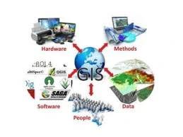
Key components of a GIS
-
Practical Exercise: Explore sample GIS datasets and identify components
-
Case Study: How GIS transformed urban planning in a major city
Module 2: Getting Started with ArcGIS
-
Overview of ArcGIS software suite
-
Installing and setting up ArcGIS
-
Interface navigation and basic tools
-
Practical Exercise: Load and visualize a sample vector dataset in ArcGIS
Module 3: Getting Started with QGIS
-
Overview of QGIS software
-
Installing and setting up QGIS
-
Interface navigation and basic tools
-
Practical Exercise: Load and edit a raster dataset in QGIS
-
Case Study: Using QGIS for community resource mapping
Module 4: Spatial Data Types, Formats, and Management
-
Vector and raster data
-
Common spatial data formats (Shapefiles, GeoTIFFs, etc.)
-
Data sources and acquisition
-
Organizing and storing spatial data
-
Editing vector and raster data
-
Attribute data management
-
Practical Exercise: Import, edit, and manage a dataset
-
Case Study: Environmental monitoring using mixed data types
Module 5: Coordinate Systems and Projections
-
Understanding coordinate systems
-
Common projections used in GIS
-
Reprojecting spatial data
-
Practical Exercise: Reproject a dataset from one coordinate system to another
Module 6: Basic Spatial Analysis
-
Overlay analysis
-
Buffering and spatial joins
-
Measuring distance and area
-
Practical Exercise: Perform buffer and overlay analysis on a sample dataset
-
Case Study: GIS-based site selection for a public facility
Module 7: Advanced Spatial Analysis Techniques
-
Spatial statistics and modeling
-
Network analysis
-
Surface analysis and interpolation
-
Practical Exercise: Conduct network and surface analysis on real-world data
Module 8: Creating Maps and Visualizations
-
Map design principles
-
Symbology and labeling
-
Creating and exporting maps
-
Practical Exercise: Design and produce thematic maps from your analysis
-
Case Study: Visualization of population density and service coverage
Module 9: Applications of GIS in Various Fields
-
Environmental management
-
Urban planning
-
Public health and epidemiology
-
Agriculture and natural resource management
-
Practical Exercise: Apply GIS analysis to a selected sector
-
Case Study: Use of GIS in disaster management
Module 10: Project Work and Integration
-
Integrating ArcGIS and QGIS workflows
-
Hands-on project using real-world data
-
Presentation and discussion of project results
-
Case Study: Comprehensive project covering data acquisition, analysis, and visualization
Where the change lands
Organisational Impact
-
Builds institutional capacity by equipping staff with foundational GIS skills applicable across multiple sectors.
-
Enhances decision-making processes through accurate spatial data analysis and mapping.
-
Increases flexibility by training staff in both proprietary (ArcGIS) and open-source (QGIS) platforms.
-
Supports diverse organisational needs such as urban planning, environmental management, disaster response, and resource monitoring.
-
Reduces dependency on external consultants by developing in-house GIS expertise.
Personal Impact
-
Provides participants with a solid foundation in GIS concepts and applications.
-
Equips learners with practical skills in both ArcGIS and QGIS, enhancing professional versatility.
-
Builds confidence in managing, analyzing, and visualizing spatial data effectively.
-
Expands career opportunities across industries that require GIS expertise.
-
Empowers participants to apply GIS techniques to real-world challenges in their field of interest.
Dates and locations
Upcoming intakes
Every intake is limited to a small cohort. Booking closes when a date fills or three weeks before the start, whichever comes first.
| City | Starts | Ends | Delivery | Book |
|---|---|---|---|---|
NakuruNext | 20 Jul 2026 | 31 Jul 2026 | In-Person | Book |
Kigali | 20 Jul 2026 | 31 Jul 2026 | In-Person | Book |
Accra | 20 Jul 2026 | 31 Jul 2026 | In-Person | Book |
Kisumu | 27 Jul 2026 | 07 Aug 2026 | In-Person | Book |
Johannesburg | 27 Jul 2026 | 07 Aug 2026 | In-Person | Book |
Dakar | 27 Jul 2026 | 07 Aug 2026 | In-Person | Book |
- NakuruNext
20 Jul → 31 Jul·In-Person
Book this intake - Kigali
20 Jul → 31 Jul·In-Person
Book this intake - Accra
20 Jul → 31 Jul·In-Person
Book this intake - Kisumu
27 Jul → 07 Aug·In-Person
Book this intake - Johannesburg
27 Jul → 07 Aug·In-Person
Book this intake - Dakar
27 Jul → 07 Aug·In-Person
Book this intake
Common questions.
Still not sure? Send us a note and a facilitator will get back to you within a business day.
You may also like.
Programmes in the same discipline that participants often pair with this course.
 Hybrid10 days
Learn AI and computer vision for urban growth monitoring and informal settlement mapping using satellite imagery, GIS, deep learning, and spatial analytics.
 Hybrid10 days
Learn AI-powered disaster damage assessment using satellite imagery, machine learning, GIS, and remote sensing for rapid response and recovery planning.
 Hybrid10 days
Learn AI-powered water body and flood extent mapping using SAR data, machine learning, GIS, and remote sensing for disaster management and water resources.
Course finder
Find the right course for you
Prefer to talk it through? Send us an enquiry and a facilitator will scope a fit within a business day.
For corporate teams
Training 10+ professionals?
We deliver Training on Introduction to GIS using ArcGIS and QGIS in-house at your offices, at a venue we arrange, or fully virtual. Customise the curriculum against your KPIs, and get a bespoke price for the cohort size you need.